
Best backcountry zones to explore near seattle
*Please Note: It's important to know that the backcountry is filled with hazards that go beyond what one might face at a ski area. There are many things to consider before getting into backcountry skiing like equipment, avalanche education, trip planning, and mentorship. Avalanche education is an important step to take for those that are interested in getting into backcountry skiing and riding. Plan to be self-sufficient with a beacon, shovel and probe for each member of your group, along with the knowledge of how to use them. Check out our previous blogs and Slay at Home Episodes for more details on all of these topics and get educated BEFORE ever venturing into the backcountry or hire a guide near you!
Check out NWAC for the forecast and a deeper understanding of what's going on with the snow.
Contributing expert:
The Washington Cascades are remote, rugged, and vast with many of our roads often snowed in or closed due to landslides. This often leaves us with 2 choices for backcountry touring: trek up from deep in the forest among the moss and ferns well below the snowline, or drive up one our dead end roads leaving the evergreens behind and ascending uphill as the snow banks along the road grow to meters overhead. Backcountry skiing in the PNW often takes hard work, persistence and a bit of grit, but the rewards are always well worth the effort.
mt baker
SWIFT CREEK, ARTIST POINT, AUSTIN PASS
skill level
terrain
guidebooks
elevation
best season
Nearest town
What hasn't already been said about Mount Baker? Baker has deep roots in snowboarding from embracing the legendary baker boot packers long before splitboards were readily available to hosting one of the most iconic snowboard competitions on earth - the Legendary Banked Slalom. Mount Baker also has arguably the best scenery of any ski area in the PNW, when it's not socked in by pouring rain. Today, Baker continues to be a mecca for backcountry skiers and riders.
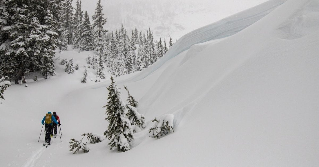
Swift creek sees a decent amount of traffic and is a really good spot to go when avalanche conditions are dangerous. Even though this area has some steeper avalanche terrain you can find plenty of low angle terrain to check out. After parking at Heather Meadows, ascend up towards Artist Point while staying outside the ski area boundary. Just after passing the backcountry gate for the ski area you are at Austin Pass, the original top of the historic ski area. From here Swift Creek spreads out below you to the east and with south and north aspects good snow lingers.
Explore around this zone and seek out short open shots through the middle, longer slopes through spaced out trees to your left (North), and dabble with steeper shots to your right (South). This classic destination will provide great opportunities to link up multiple lines, dial transitions, and seek out aspect dependent snow quality.
1) Swift Creek (Rider: Jere Burrell, Photo: Mike Leeuw)
2) (Rider: Jere Burrell, Photo: Jen Cole)
For more details and zones in the Mount Baker Area check out Matt Schonwald’s Book Backcountry Skiing - Mt. Baker, Washington. Better yet, book Jere as a guide! Caltopo also offers a lot of info on this zone here.
stevens pass
SKYLINE DIVIDE
skill level
terrain
elevation
best season
nearest town
The drive up to Steven’s Pass can be hectic on the weekend. Start early to make sure you get a parking spot to head up Skyline Ridge. Plan a quick pit stop at the Espresso Chalet and check out their extensive collection of Bigfoot memorabilia.
Ascending up the old road bed quickly puts you onto the ridge where you will find a variety of aspects and terrain options. After reaching the ridge the shots directly below can be fun when filled in, but also become challenging with drops, gullies, and terrain traps. If the conditions or your ability prevent you from riding these lines - trend to your left or west along the ridge. Eventually you'll find mellower slopes and good warm up runs. This drainage has 2 ridges that extend North East and as you head out on these ridges the terrain steepens and grows in height.
When conditions are stable these slopes offer long descents on sweet terrain. These options also pose an important consideration: Do you skin back up the valley to Skyline and back down to your car or continue down valley eventually linking into the Yodelin exit back to your previously shuttled car. You may also be able to hitch hike back up to your car at the top of the pass if you did not drop a car to shuttle back up.
The Lantham Lake approach is another great option to explore this area and avoid the parking issues up at the pass! You will find plenty of fun moderate terrain with open alpine when avy danger allows it.
snoqualmie pass
KENDALL STUMP & TREES
skill level
terrain
guidebookS
elevation
best season
nearest town
The terrain, snow, and access here are the epitome of the Cascadian ski experience. At 40 minutes from Seattle this heavy hitting powder house delivers ample snow and steep terrain. It also offers easy enough access for before work laps or to cut out at lunch for some hot laps.
After exiting at Snoqualmie Pass exit hard right into the first parking lot. To start your tour, cross back under the highway on foot and enter the trees on the right side of the road. This will lead to the Pacific Crest Trail summer trailhead. Navigating the forest here can be tricky but continue ascending ENE after 1,100 feet of climbing you'll trend a bit more east under some steeper cliffs.
Alternatively head east early and enter the old clear cut. Either way you'll reach the Kendall Stump at 4,700’. Again this summit offers descents on every aspect. Some which will cliff out, especially west and nw, so choose your lines wisely. From here the ridgeline leads to fun descents down to Kendall Peak Lakes, down west in the trees or the most direct line back towards the highway and your car leads through the old clear cut. This zone offers quick access terrain where practically every step gains elevation though beautiful forests. After half an hour or so you can access an old clear cut that delivers open glades. If you're looking to step it up from Hyak this will be a good training ground to explore the bigger terrain of the Commonwealth and Alpental Valleys.
Jere riding Kendall trees in stable conditions. Photo: Lyra Pierotti
The Kendal Adventure Zone offers expert only terrain and big days in the backcountry. For more info on this zone and many others check out Schonwald’s Book - Backcountry Skiing Snoqualmie Pass, Washington.